dhis2-users team mailing list archive
-
 dhis2-users team
-
Mailing list archive
-
Message #11325
Re: Tacker villages
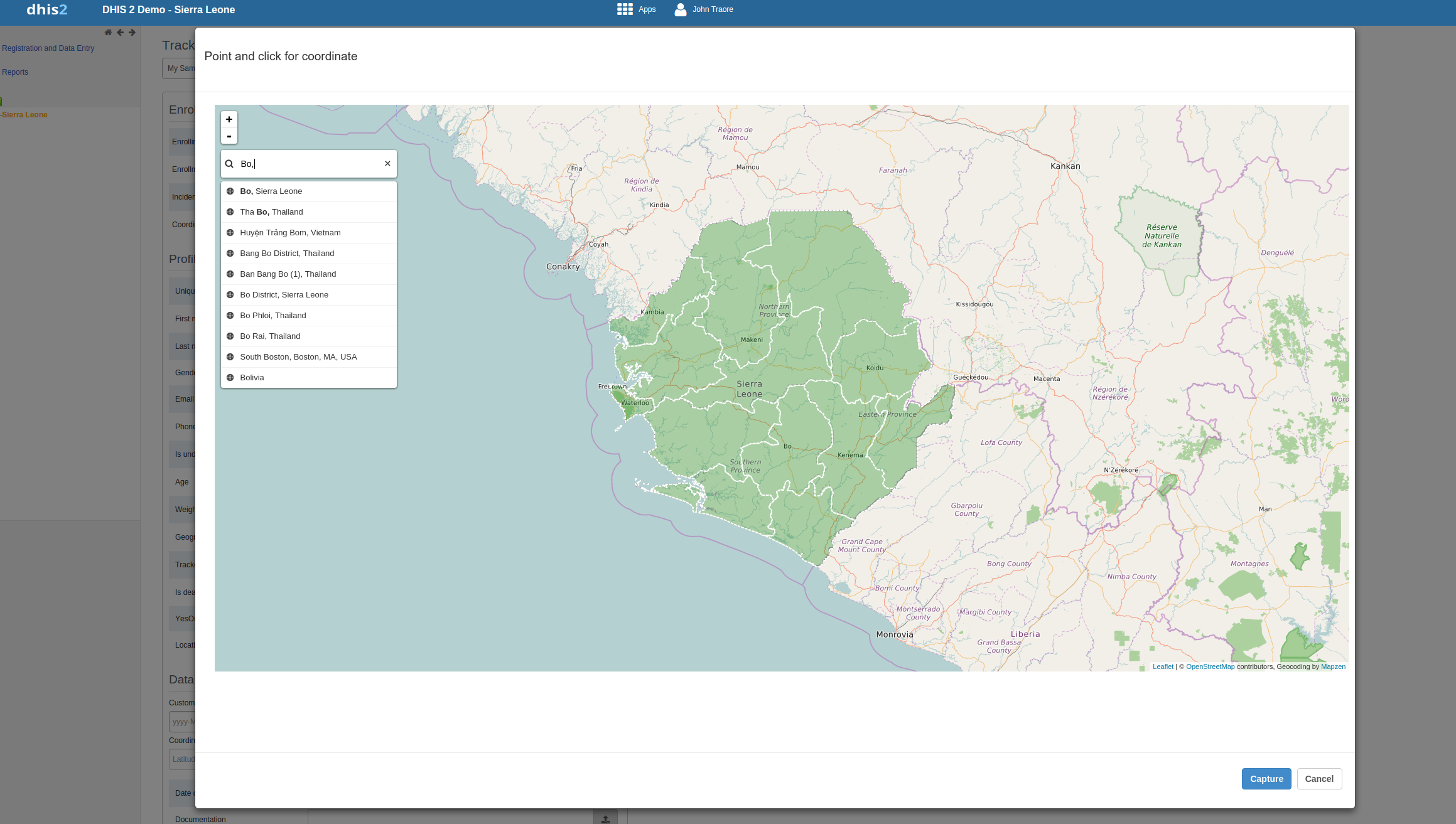
@Knut,

yes, you search in the map. It is optional and text search. Once you have
searched for an area and picked the right one, the system takes the
corresponding coordinate and saves the lat/lng.

[image: Inline image 1]


@Ranga

1. Mapzen and its area search is not yet integrated with our android
tracker apps.
2. For the web version of tracker: I am not sure, but if the API (mapzen
search api) supports we could narrow down the search to focus on specific
region.

--
Abyot A. Gizaw.
Senior Engineer, DHIS2
University of Oslo
http://www.dhis2.org

On Wed, Sep 14, 2016 at 10:33 AM, Knut Staring <knutst@xxxxxxxxx> wrote:

> Ok great, I was confused because you talked about searching "in the map",
> which I guess is optional (it is mainly a text search)?
>
> On Wed, Sep 14, 2016 at 10:15 AM, Abyot Asalefew Gizaw <abyot@xxxxxxxxx>
> wrote:
>
>> Name searching is coming in 2.25, that is what I meant with the first
>> possibility.
>>
>> ---
>>
>> Thank you,
>> Abyot.
>> (sent from mobile)
>>
>> On Sep 14, 2016 10:06, "Knut Staring" <knutst@xxxxxxxxx> wrote:
>>
>>> I am thinking that actually there could be another possibility as well,
>>> though it is probably not quite availble yet, namely to use the name search
>>> service which is already integrated in the new GIS module (second button
>>> from the bottom up on the right hand side here: https://play.dhis2.org/d
>>> emo/dhis-web-mapping/)
>>>
>>> AND/OR it could also be interesting to be able to populate option sets
>>> based on the place names (with coordinates attached) provided by that
>>> service.
>>>
>>> Knut
>>>
>>> On Wed, Sep 14, 2016 at 9:07 AM, Abyot Asalefew Gizaw <abyot@xxxxxxxxx>
>>> wrote:
>>>
>>>> Dear Lise,
>>>>
>>>> One possibility is to use our new (coming in 2.25) coordinate capture
>>>> UI. It uses mapzen <http:///> that allows you to search for areas
>>>> directly in the map and capture their coordinates. This could help in
>>>> capturing consistent coordinates.
>>>>
>>>> An issue though is, will all your villages be in mapzen's area
>>>> database. See here for more https://mapzen.com/docume
>>>> ntation/search/data-sources/
>>>>
>>>> A second possibility is to use option sets. How many villages are you
>>>> expecting? We are not loading options in drop down all at once. We use
>>>> paging+searching and each time we will only have a maximum of 30 options
>>>> displayed in the dropdown.
>>>>
>>>> --
>>>> Abyot A. Gizaw.
>>>> Senior Engineer, DHIS2
>>>> University of Oslo
>>>> http://www.dhis2.org
>>>>
>>>> On Wed, Sep 14, 2016 at 8:28 AM, GROUT, Lise <groutl@xxxxxxx> wrote:
>>>>
>>>>> Dear Alex,
>>>>>
>>>>>
>>>>> Thank you for your answer.
>>>>>
>>>>>
>>>>>
>>>>> I already have a data element as coordinate in the form (actually it
>>>>> is rather an attribute). But each time your register a patient, even if he
>>>>> lives in the same village than a former patient, you will record slightly
>>>>> different coordinates, the point will be slightly different. What I would
>>>>> like is to be able to record the village of residence in a way that make it
>>>>> useful for analysis (if it is free text, it cannot be used directly).
>>>>>
>>>>>
>>>>>
>>>>> Thanks
>>>>>
>>>>>
>>>>>
>>>>> Lise
>>>>>
>>>>>
>>>>>
>>>>> *From:* Alex Tumwesigye [mailto:atumwesigye@xxxxxxxxx]
>>>>> *Sent:* 14 September 2016 08:25
>>>>> *To:* GROUT, Lise
>>>>> *Cc:* DHIS 2 Users list
>>>>> *Subject:* Re: [Dhis2-users] Tacker villages
>>>>>
>>>>>
>>>>>
>>>>> Dear Lise,
>>>>>
>>>>>
>>>>>
>>>>> You can create an attribute or data element of value type
>>>>> 'coordinate'. This will allow  you to capture coordinates.
>>>>>
>>>>>
>>>>>
>>>>> Alex
>>>>>
>>>>>
>>>>>
>>>>> On Tue, Sep 13, 2016 at 5:35 PM, GROUT, Lise <groutl@xxxxxxx> wrote:
>>>>>
>>>>> Dear all,
>>>>>
>>>>>
>>>>>
>>>>> I am working on several Tracker programs, and we will be recording the
>>>>> village of origin.
>>>>>
>>>>>
>>>>>
>>>>> Tacker enables to captures coordinates, but they will be (most
>>>>> probably) different from one case to the other as it is designed to be able
>>>>> to map the exact location of the entity. And I know you can then use the
>>>>> new cluster  features in GIS.
>>>>>
>>>>>
>>>>>
>>>>> But I would like to aggregate the cases by villages of provenance.
>>>>> Having one free text box to indicate the village name is not useful for
>>>>> this. So I am wondering if any of you have already found wise ways of doing
>>>>> it.
>>>>>
>>>>>
>>>>>
>>>>> Here are my first ideas, but would like to have your opinion before
>>>>> testing them:
>>>>>
>>>>> 1)      Create org units for each village, but:
>>>>>
>>>>> a.      I fear the org unit will be very long to charge then
>>>>>
>>>>> b.      The cases are registered at health facility level in the org
>>>>> unit tree, not village level
>>>>>
>>>>> 2)      Create an option set with villages, but:
>>>>>
>>>>> a.      I fear it will be impossible to load…
>>>>>
>>>>> b.      Don’t know if it can be dynamic (if you choose a district,
>>>>> you just see the villages of this district) (I think I was told it was not
>>>>> possible to do)
>>>>>
>>>>> 3)      Create a program to register the villages, and use the
>>>>> relationship feature (my favourite idea so far, anyone tried it?)
>>>>>
>>>>> 4)      Create a program to register the villages, and use them
>>>>> through another path. I know Uganda HISP showed something in Oslo, but I
>>>>> imagine this require coding?
>>>>>
>>>>>
>>>>>
>>>>> Looking forward to reading your ideas!
>>>>>
>>>>>
>>>>>
>>>>> Lise
>>>>>
>>>>>
>>>>>
>>>>>
>>>>>
>>>>>
>>>>>
>>>>> Dr. Lise Grout
>>>>>
>>>>> *Epidemiologist*
>>>>>
>>>>>
>>>>>
>>>>> *World Health Organization*
>>>>>
>>>>> *Department of Neglected Tropical Diseases (HTM/NTD/IDM)*
>>>>> *Innovative and Intensified Disease Management Unit*
>>>>> *20, Avenue Appia; CH-1211 Geneva 27*
>>>>> *Tel. **+41 22 791 2341 <%2B41%2022%20791%202341>*
>>>>>
>>>>> *Mobile +41 79 290 68 61 <%2B41%2079%20290%2068%2061>*
>>>>>
>>>>> *Skype: tigrouveto*
>>>>>
>>>>> http://www.who.int/neglected_diseases
>>>>>
>>>>>
>>>>>
>>>>>
>>>>> _______________________________________________
>>>>> Mailing list: https://launchpad.net/~dhis2-users
>>>>> Post to     : dhis2-users@xxxxxxxxxxxxxxxxxxx
>>>>> Unsubscribe : https://launchpad.net/~dhis2-users
>>>>> More help   : https://help.launchpad.net/ListHelp
>>>>>
>>>>>
>>>>>
>>>>>
>>>>>
>>>>> --
>>>>>
>>>>> Alex Tumwesigye
>>>>>
>>>>>
>>>>>
>>>>> Technical Advisor - DHIS2 (Consultant),
>>>>> Ministry of Health/AFENET  | HISP Uganda
>>>>>
>>>>> Kampala
>>>>>
>>>>> Uganda
>>>>> +256 774149 775, + 256 759 800161
>>>>>
>>>>> Skype ID: talexie
>>>>>
>>>>>
>>>>> IT Consultant (Servers, Networks and Security, Health Information
>>>>> Systems - DHIS2, Disease Outbreak & Surveillance Systems) & Solar Consultant
>>>>>
>>>>>
>>>>> "I don't want to be anything other than what I have been - one tree
>>>>> hill "
>>>>>
>>>>> _______________________________________________
>>>>> Mailing list: https://launchpad.net/~dhis2-users
>>>>> Post to     : dhis2-users@xxxxxxxxxxxxxxxxxxx
>>>>> Unsubscribe : https://launchpad.net/~dhis2-users
>>>>> More help   : https://help.launchpad.net/ListHelp
>>>>>
>>>>>
>>>>
>>>> _______________________________________________
>>>> Mailing list: https://launchpad.net/~dhis2-users
>>>> Post to     : dhis2-users@xxxxxxxxxxxxxxxxxxx
>>>> Unsubscribe : https://launchpad.net/~dhis2-users
>>>> More help   : https://help.launchpad.net/ListHelp
>>>>
>>>>
>>>
>>>
>>> --
>>> Knut Staring
>>> Dept. of Informatics, University of Oslo
>>> Norway: +4791880522
>>> Skype: knutstar
>>> http://dhis2.org
>>>
>>
>
>
> --
> Knut Staring
> Dept. of Informatics, University of Oslo
> Norway: +4791880522
> Skype: knutstar
> http://dhis2.org
>
Follow ups
References