| Thread Previous • Date Previous • Date Next • Thread Next |
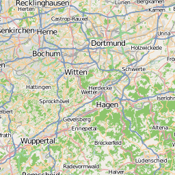
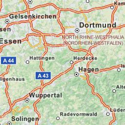
Hello,

The background of my question is, that I often travel to places where
you do not have access to Internet via data mobile. In my netbook with
FreeBSD I'm using foxtrotGPS and pre-fetched tiles, i.e. they are already
stored in the disk and foxtroGPS makes use of the png-files. There is a
small C-written tool which generates all tiles file names for the two
coordinates of a rectangle you give to that tool.
Than one just uses wget to fetch down the ~1000000 tiles and you have
them stored in the disk for offline usage.

The name structure is the same as in the OSM server, i.e. for example:

9/266/170.png

The OSMTouch app caches the tiles below /home/phablet/.cache/me.yohanboniface.osmtouch/

and the tiles for that same place has for the OSMTouch the name

osm_100-1-9-266-170.png

Both cover the same region of the map in zoom level 9. So far so good.

I was thinking to copy over the tiles from my netbook to the BQ and just
generating on the fly the correct names osm_100-1-.....

But, I have compared the files and they have a different look and feel (both
attached). Anybody knows why they are different?

Thanks

	matthias

--
Matthias Apitz, guru@xxxxxxxxxxx, http://www.unixarea.de/ +49-170-4527211    +49-176-38902045
"Wenn der Mensch von den Umständen gebildet wird, so muß man die Umstände menschlich bilden."
"Si el hombre es formado por las circunstancias entonces es necesario formar humanamente
las circunstancias", Karl Marx in Die heilige Familie / La sagrada familia (MEW 2, 138)
Attachment:
170.png
Description: PNG image
Attachment:
osm_100-1-9-266-170.png
Description: PNG image
| Thread Previous • Date Previous • Date Next • Thread Next |